
Exclusive: Laser Scans Reveal Maya "Megalopolis" Below Guatemalan Jungle
In whats being hailed as a major breakthrough in Maya archaeology, researchers have identified the ruins of more than 60,000 houses, palaces, elevated highways, and other human-made features that have been hidden for centuries under the jungles of northern Guatemala.
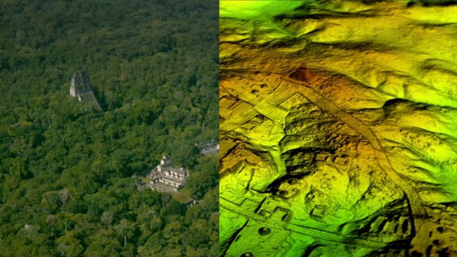
Using a revolutionary technology known as LiDAR (short for Light Detection And Ranging), scholars digitally removed the tree canopy from aerial images of the now-unpopulated landscape, revealing the ruins of a sprawling pre-Columbian civilization that was far more complex and interconnected than most Maya specialists had supposed.
The LiDAR images make it clear that this entire region was a settlement system whose scale and population density had been grossly underestimated, said Thomas Garrison, an Ithaca College archaeologist and National Geographic Explorer who specializes in using digital technology for archaeological research.
Garrison is part of a consortium of researchers who are participating in the project, which was spearheaded by the PACUNAM Foundation, a Guatemalan nonprofit that fosters scientific research, sustainable development, and cultural heritage preservation.
The project mapped more than 800 square miles (2,100 square kilometers) of the Maya Biosphere Reserve in the Petén region of Guatemala, producing the largest LiDAR data set ever obtained for archaeological research.
The results suggest that Central America supported an advanced civilization that was, at its peak some 1,200 years ago, more comparable to sophisticated cultures such as ancient Greece or China than to the scattered and sparsely populated city states that ground-based research had long suggested.
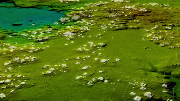
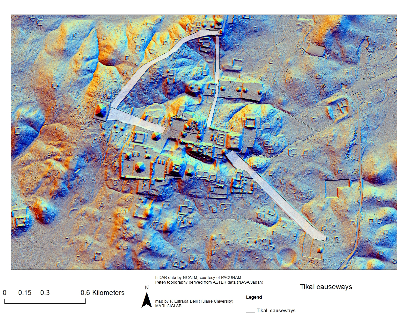
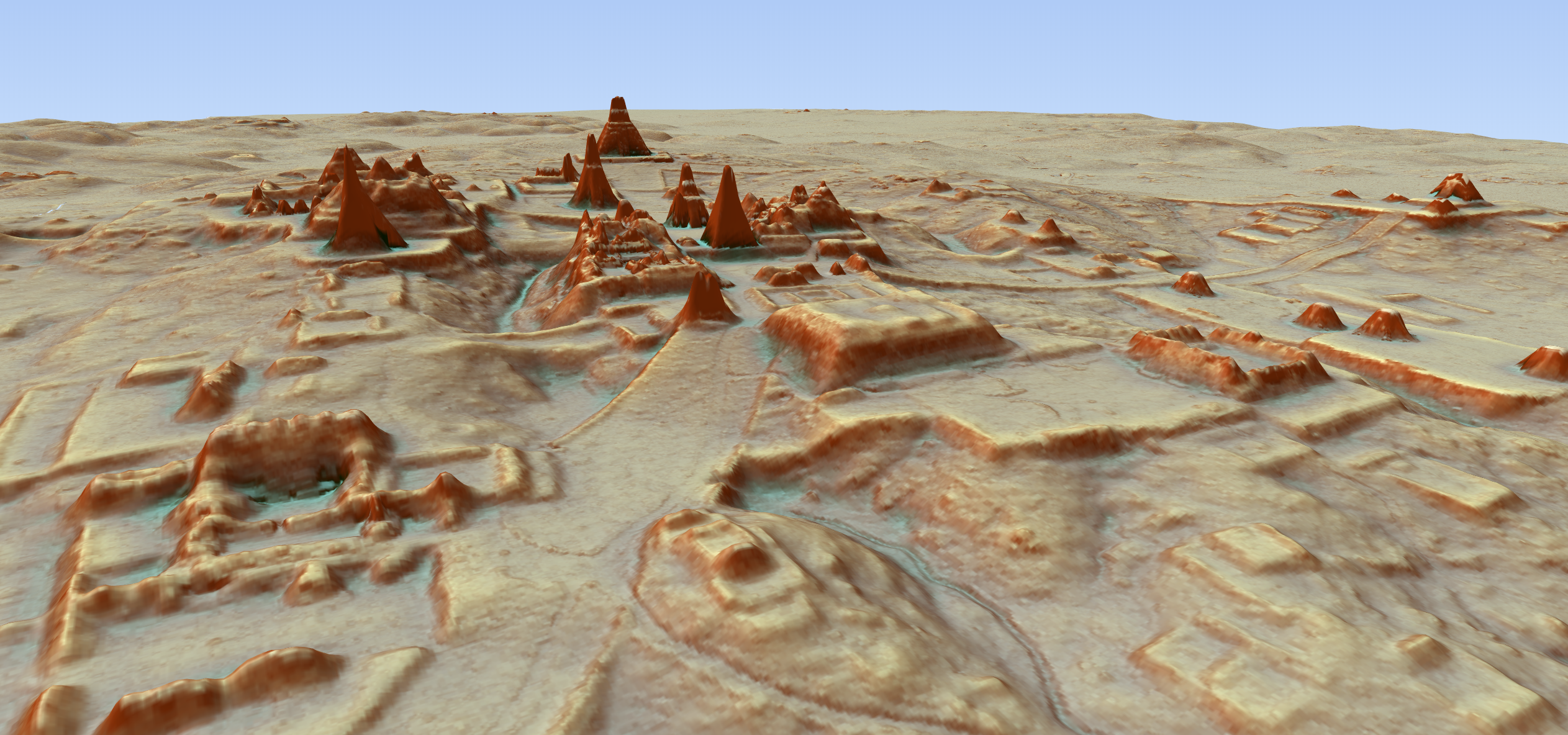
In addition to hundreds of previously unknown structures, the LiDAR images show raised highways connecting urban centers and quarries. Complex irrigation and terracing systems supported intensive agriculture capable of feeding masses of workers who dramatically reshaped the landscape.
The ancient Maya never used the wheel or beasts of burden, yet this was a civilization that was literally moving mountains, said Marcello Canuto, a Tulane University archaeologist and National Geographic Explorer who participated in the project.
Weve had this western conceit that complex civilizations cant flourish in the tropics, that the tropics are where civilizations go to die, said Canuto, who conducts archaeological research at a Guatemalan site known as La Corona. But with the new LiDAR-based evidence from Central America and [Cambodias] Angkor Wat, we now have to consider that complex societies may have formed in the tropics and made their way outward from there.
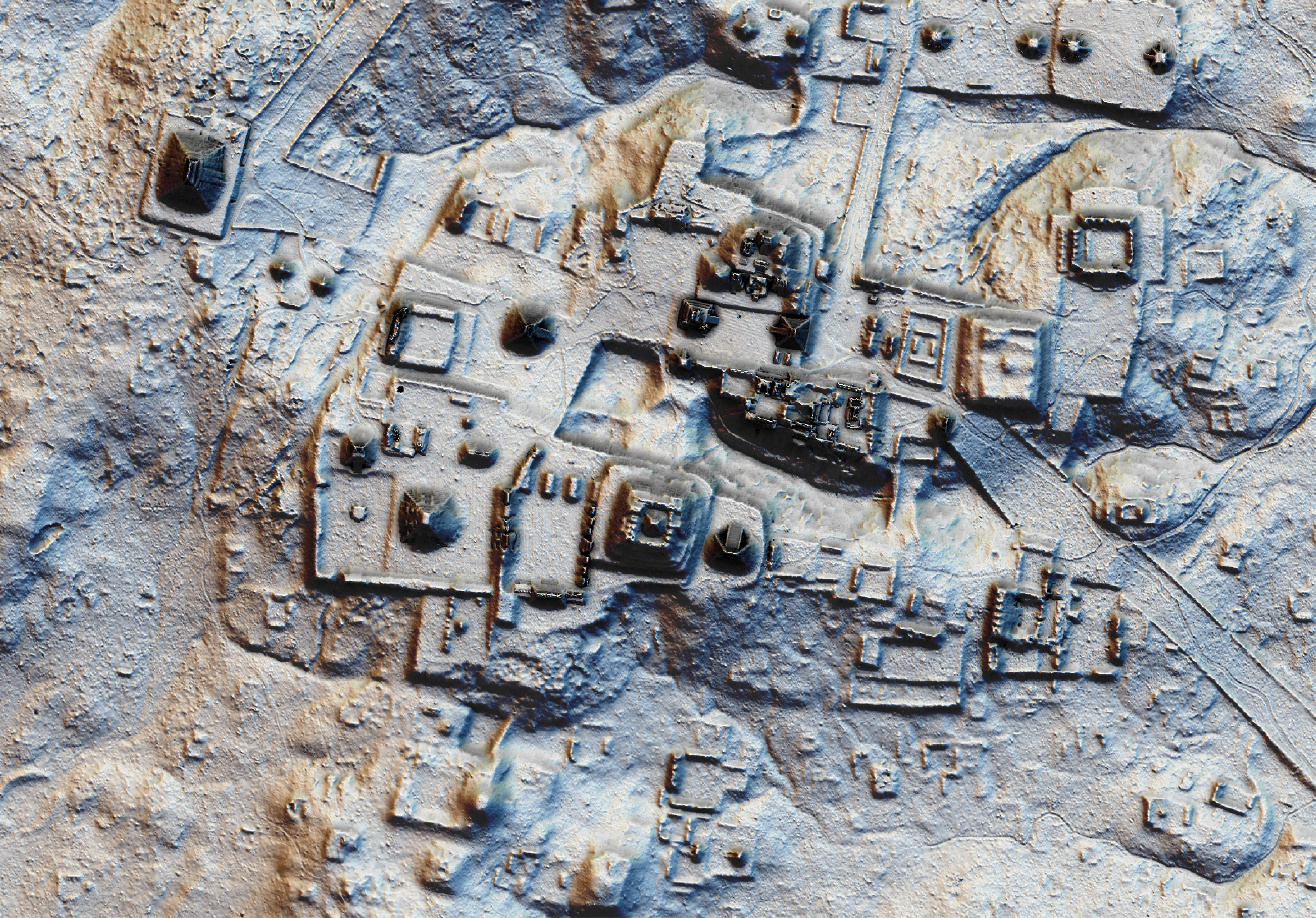
Laser technology known as LiDAR digitally removes the forest canopy to reveal ancient ruins below, showing that Maya cities such as Tikal were much larger than ground-based research had suggested.
In whats being hailed as a major breakthrough in Maya archaeology, researchers have identified the ruins of more than 60,000 houses, palaces, elevated highways, and other human-made features that have been hidden for centuries under the jungles of northern Guatemala.
Laser scans revealed more than 60,000 previously unknown Maya structures that were part of a vast network of cities, fortifications, farms, and highways.
Courtesy Wild Blue Media/National Geographic
Using a revolutionary technology known as LiDAR (short for Light Detection And Ranging), scholars digitally removed the tree canopy from aerial images of the now-unpopulated landscape, revealing the ruins of a sprawling pre-Columbian civilization that was far more complex and interconnected than most Maya specialists had supposed.
The LiDAR images make it clear that this entire region was a settlement system whose scale and population density had been grossly underestimated, said Thomas Garrison, an Ithaca College archaeologist and National Geographic Explorer who specializes in using digital technology for archaeological research.
Garrison is part of a consortium of researchers who are participating in the project, which was spearheaded by the PACUNAM Foundation, a Guatemalan nonprofit that fosters scientific research, sustainable development, and cultural heritage preservation.
The project mapped more than 800 square miles (2,100 square kilometers) of the Maya Biosphere Reserve in the Petén region of Guatemala, producing the largest LiDAR data set ever obtained for archaeological research.
The results suggest that Central America supported an advanced civilization that was, at its peak some 1,200 years ago, more comparable to sophisticated cultures such as ancient Greece or China than to the scattered and sparsely populated city states that ground-based research had long suggested.
In addition to hundreds of previously unknown structures, the LiDAR images show raised highways connecting urban centers and quarries. Complex irrigation and terracing systems supported intensive agriculture capable of feeding masses of workers who dramatically reshaped the landscape.
The ancient Maya never used the wheel or beasts of burden, yet this was a civilization that was literally moving mountains, said Marcello Canuto, a Tulane University archaeologist and National Geographic Explorer who participated in the project.
Weve had this western conceit that complex civilizations cant flourish in the tropics, that the tropics are where civilizations go to die, said Canuto, who conducts archaeological research at a Guatemalan site known as La Corona. But with the new LiDAR-based evidence from Central America and [Cambodias] Angkor Wat, we now have to consider that complex societies may have formed in the tropics and made their way outward from there.
Surprising Insights
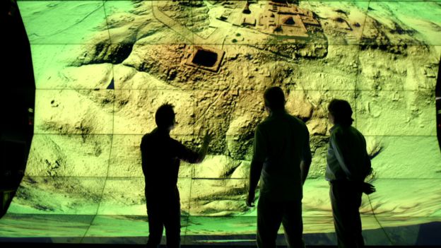
LiDAR is revolutionizing archaeology the way the Hubble Space Telescope revolutionized astronomy, said Francisco Estrada-Belli, a Tulane University archaeologist and National Geographic Explorer. Well need 100 years to go through all [the data] and really understand what were seeing.
Already, though, the survey has yielded surprising insights into settlement patterns, inter-urban connectivity, and militarization in the Maya Lowlands. At its peak in the Maya classic period (approximately A.D. 250900), the civilization covered an area about twice the size of medieval England, but it was far more densely populated.
Most people had been comfortable with population estimates of around 5 million, said Estrada-Belli, who directs a multi-disciplinary archaeological project at Holmul, Guatemala.
With this new data its no longer unreasonable to think that there were 10 to 15 million people thereincluding many living in low-lying, swampy areas that many of us had thought uninhabitable.


 Reply With Quote


Bookmarks