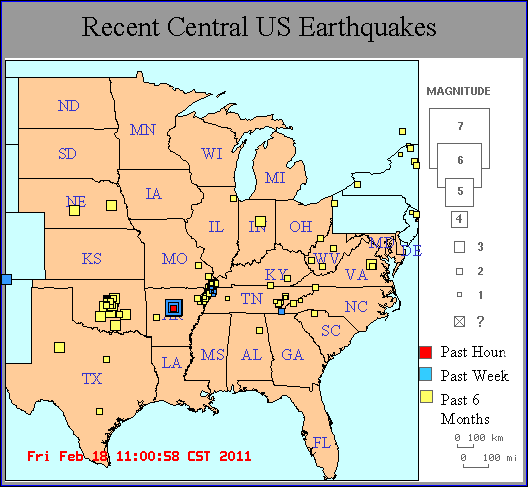
 Posted by stomy
(here)
3) Mississipi
Historic Earthquakes
New Madrid Earthquakes 1811-1812
Posted by stomy
(here)
3) Mississipi
Historic Earthquakes
New Madrid Earthquakes 1811-1812

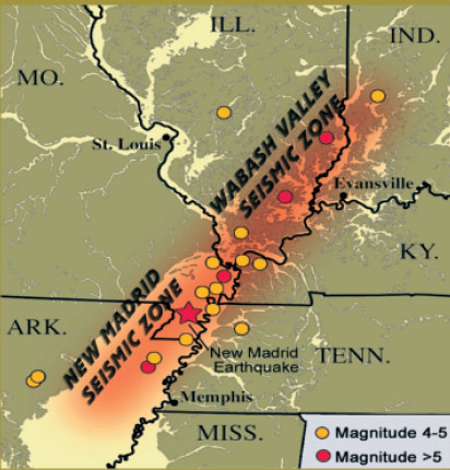
This sequence of three very large earthquakes is usually referred to as the New Madrid earthquakes, after the Missouri town that was the largest settlement on the Mississippi River between St. Louis, Missouri and Natchez, Mississippi. On the basis of the large area of damage (600,000 square kilometers), the widespread area of perceptibility (5,000,000 square kilometers), and the complex physiographic changes that occurred, the New Madrid earthquakes of 1811-1812 rank as some of the largest in the United States since its settlement by Europeans. They were by far the largest east of the Rocky Mountains in the U.S. and Canada. The area of strong shaking associated with these shocks is two to three times as large as that of the 1964 Alaska earthquake and 10 times as large as that of the 1906 San Francisco earthquake. Because there were no seismographs in North America at that time, and very few people in the New Madrid region, the estimated magnitudes of this series of earthquakes vary considerably and depend on modern researchers' interpretations of journals, newspaper reports, and other accounts of the ground shaking and damage. The magnitudes of the three principal earthquakes of 1811-1812 described below are the preferred values taken from research involved with producing the 2008 USGS National Seismic Hazard Map (
http://pubs.usgs.gov/of/2008/1128/).
The first principal earthquake,
M7.7, occurred at about 2:15 am (local time) in northeast Arkansas on December 16, 1811. The second principal shock, M7.5, occurred in Missouri on January 23, 1812, and the third, M7.7, on February 7, 1812, along the Reelfoot fault in Missouri and Tennessee. The earthquake ground shaking was not limited to these principal main shocks, as there is evidence for a fairly robust aftershock sequence. The first and largest aftershock occurred on December 16, 1811 at about 7:15 am. At least three other large aftershocks are inferred from historical accounts on December 16 and 17. These three events are believed to range between M6.0 and 6.5 in size and to be located in Arkansas and Missouri. This would make a total of seven earthquakes of magnitude M6.0-7.7 occurring in the period December 16, 1811 through February 7, 1812. In total, Otto Nuttli reported more than 200 moderate to large aftershocks in the New Madrid region between December 16, 1811, and March 15, 1812: ten of these were greater than about 6.0; about one hundred were between M5.0 and 5.9; and eighty-nine were in the magnitude 4 range. Nuttli also noted that about eighteen hundred earthquakes of about M3.0 to 4.0 during the same period.
The first earthquake of December 16, 1811 caused only slight damage to man-made structures, mainly because of the sparse population in the epicentral area. The extent of the area that experienced damaging earth motion, which produced Modified Mercalli Intensity greater than or equal to VII, is estimated to be 600,000 square kilometers. However, shaking strong enough to alarm the general population (intensity greater than or equal to V) occurred over an area of 2.5 million square kilometers.
The earthquakes caused the ground to rise and fall - bending the trees until their branches intertwined and opening deep cracks in the ground. Deep seated landslides occurred along the steeper bluffs and hillslides; large areas of land were uplifted permanently; and still larger areas sank and were covered with water that erupted through fissures or craterlets. Huge waves on the Mississippi River overwhelmed many boats and washed others high onto the shore. High banks caved and collapsed into the river; sand bars and points of islands gave way; whole islands disappeared. Surface fault rupturing from these earthquakes has not been detected and was not reported, however. The region most seriously affected was characterized by raised or sunken lands, fissures, sinks, sand blows, and large landslides that covered an area of 78,000 - 129,000 square kilometers, extending from Cairo, Illinois, to Memphis, Tennessee, and from Crowley's Ridge in northeastern Arkansas to Chickasaw Bluffs, Tennessee. Only one life was lost in falling buildings at New Madrid, but chimneys were toppled and log cabins were thrown down as far distant as Cincinnati, Ohio, St. Louis, Missouri, and in many places in Kentucky, Missouri, and Tennessee.
The Lake County uplift, about 50 kilometers long and 23 kilometers wide, stands above the surrounding Mississippi River Valley by as much as 10 meters in parts of southwest Kentucky, southeast Missouri, and northwest Tennessee. The uplift apparently resulted from vertical movement along several, ancient, subsurface faults. Most of the uplift occurred during prehistoric earthquakes. A strong correlation exists between modern seismicity and the uplift, indicating that stresses that produced the uplift may still exist today.
Within the Lake County uplift, Tiptonville dome, which is about 14 kilometers in width and 11 kilometers in length, shows the largest upwarping and the highest topographic relief. It is bounded on the east by 3-m high Reelfoot scarp. Although most of Tiptonville dome formed between 200 and 2,000 years ago, additional uplifting deformed the northwest and southeast parts of the dome during the earthquakes of 1811-1812.
A notable area of subsidence that formed during the February 7, 1812, earthquake is Reelfoot Lake in Tennessee, just east of Tiptonville dome on the downdropped side of the Reelfoot scarp. Subsidence there ranged from 1.5 to 6 meters, although larger amounts were reported.
Other areas subsided by as much as 5 meters, although 1.5 to 2.5 meters was more common. Lake St. Francis, in eastern Arkansas, which was formed by subsidence during both prehistoric and the 1811-182 earthquakes, is 64 kilometers long by 1 kilometer wide. Coal and sand were ejected from fissures in the swamp land adjacent to the St. Francis River, and the water level is reported to have risen there by 8 to 9 meters.
Large waves (seiches) were generated on the Mississippi River by seismically-induced ground motions deforming the riverbed. Local uplifts of the ground and water waves moving upstream gave the illusion that the river was flowing upstream. Ponds of water also were agitated noticeably.
1811, December 16, 08:15 UTC Northeast Arkansas - the first main shock
2:15 am local time
Magnitude ~7.7
This powerful earthquake was felt widely over the entire eastern United States. People were awakened by the shaking in New York City, Washington, D.C., and Charleston, South Carolina. Perceptible ground shaking was in the range of one to three minutes depending upon the observers location. The ground motions were described as most alarming and frightening in places like Nashville, Tennesse, and Louisville, Kentucky. Reports also describe houses and other structures being severely shaken with many chimneys knocked down. In the epicentral area the ground surface was described as in great convulsion with sand and water ejected tens of feet into the air (liquefaction).
1811, December 16, 13:15 UTC Northeast Arkansas - the "Dawn" Aftershock
7:15 am local time
Magnitude ~7.0
A large event felt on the East Coast that is sometimes regarded as the fourth principal earthquake of the 1811-1812 sequence. The event is described as "severe" at New Bourbon, Missouri, and was described by boatman John Bradbury, who was moored to a small island south of New Madrid, as "terrible, but not equal to the first". Hough believes that this large aftershock occurred around dawn in the New Madrid region near the surface projection of the Reelfoot fault.
1812, January 23, 15:15 UTC, New Madrid, Missouri
9:15 am local time,
Magnitude ~7.5
The second principal shock of the 1811-1812 sequence.
It is difficult to assign intensities to the principal shocks that occurred after 1811 because many of the published accounts describe the cumulative effects of all the earthquakes and because the Ohio River was iced over, so there was little river traffic and fewer human observers. Using the December 16 earthquake as a standard, however, there is a general consensus that this earthquake was the smallest of the three principals. The meizoseismal area was characterized by general ground warping, ejections, fissuring, severe landslides, and caving of stream banks.
1812, February 7, 09:45 UTC, New Madrid, Missouri
3:45 am local time,
Magnitude ~7.7
The third principal earthquake of the 1811-1812 series.
Several destructive shocks occurred on February 7, the last of which equaled or surpassed the magnitude of any previous event. The town of New Madrid was destroyed. At St. Louis, many houses were damaged severely and their chimneys were thrown down. The meizoseismal area was characterized by general ground warping, ejections, fissuring, severe landslides, and caving of stream banks.
Source:
USGS


 Reply With Quote


Bookmarks