


Evidence Of Lost Continent Of Mu Found? Sunken Islands Could Cause Tectonic Shift In Gondwana Story
In the remote waters of the Indian Ocean, west of Perth, scientists have just discovered two sunken islands, almost the size of Tasmania, which were once part of the supercontinent Gondwana.
"The data collected on the voyage could significantly change our understanding of the way in which India, Australia and Antarctica broke off from Gondwana," said Dr Joanne Whittaker http://www.geosci.usyd.edu.au/people/st_whittaker.shtml, a postdoctoral fellow at the University of Sydney's School of Geosciences.
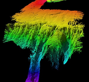
A sonar image of the underwater land masses
Researchers from the University of Sydney, Macquarie University and the University of Tasmania led an international team of scientists on the voyage to map the seafloor of the Perth Abyssal Plain. The expedition returned to Perth last week after a three-week cruise.
Travelling on the CSIRO vessel Southern Surveyor the scientists discovered the islands through detailed seafloor mapping and by dredging rock samples from the steep slopes of the two islands, now in water depths of over 1.5km
"The sunken islands charted during the expedition have flat tops, which indicates they were once at sea level before being gradually submerged," said Dr Whittaker.
Collecting rocks from the abyss more than 1.5km below the surface was not easy, but the geologists managed to retrieve hundreds of kilograms and unexpectedly found rocks that showed the islands had not always been underwater.
The University of Sydney's Dr Simon Williams, the chief scientist on the expedition said: "We expected to see common oceanic rocks such as basalt in the dredge, but were surprised to see continental rocks such as granite, gneiss and sandstone containing fossils."
In the Cretaceous period when dinosaurs roamed the Earth (more than 130 million years ago), India was adjacent to Western Australia. When India began to break away from Australia, the islands formed part of the last link between the two continents.
Eventually these islands, referred to as 'micro-continents' by scientists, were separated from both landmasses and stranded in the Indian Ocean, thousands of kilometres from the Australian and Indian coasts.
Dr Williams commented: "A detailed analysis of the rocks dredged up during the voyage will tell us about their age and how they fit into the Gondwana jigsaw."
Dr Whittaker - who applied for the successful grant that made the expedition possible, but was unable to take part in the voyage due to the recent birth of her baby - said the discovery is a significant development for her field. "Our preliminary analysis of the magnetic data that we collected could cause us to rethink the whole plate tectonic story for the whole of the eastern Indian Ocean," she said.
The expedition took place aboard the Marine National Facility's Research Vessel Southern Surveyor, which is owned and managed by the Commonwealth Scientific and Industrial Research Organisation, with its operations funded by the Australian government and overseen by a government-appointed steering committee.
Lost continent of Mu
The discovery brings to my mind the legends of the Lost Continent of Mu, the Motherland of Man.
Mu, as a lost Pacific Ocean continent, was popularized by James Churchward (18511936) in a series of books, beginning with Lost Continent of Mu, the Motherland of Man (1926), re-edited later as The Lost Continent Mu (1931). Other popular books in the series are The Children of Mu (1931), and The Sacred Symbols of Mu (1933). (I was fascinated by these books which I read during high school.)
Purported location of the continent of Mu
Churchward claimed that "more than fifty years ago," while he was a soldier in India, he befriended a high-ranking temple priest who showed him a set of ancient "sunburnt" clay tablets, supposedly in a long lost "Naga-Maya language" which only two other people in India could read. Having mastered the language himself, Churchward found out that they originated from "the place where [man] first appearedMu." The 1931 edition states that all matter of science in this work are based on translations of two sets of ancient tablets: the clay tables he read in India, and a collection 2,500 stone tablets that had been uncovered by William Niven in Mexico.
Churchward claimed that Mu was the common origin of the great civilizations of Egypt, Greece, Central America, India, Burma and others, including Easter Island, and was in particular the source of ancient megalithic architecture. As evidence for his claims, he pointed to symbols from throughout the world, in which he saw common themes of birds, the relation of the Earth and the sky, and especially the Sun. Churchward claims the king of Mu was Ra and he relates this to the Egyptian god of the sun, Ra, and the Rapanui word for Sun, raa, which he incorrectly spells "raa." He claimed to have found symbols of the Sun in Egypt, Babylonia, Peru and all ancient lands and countries it was a universal symbol.?
Churchward attributed all megalithic art in Polynesia to the people of Mu. He claimed that symbols of the sun are found depicted on stones of Polynesian ruins, such as the stone hats (pukao) on top of the giant moai statues of Easter Island
Citing W.J. Johnson, Churchward describes the cylindrical hats as spheres that "seem to show red in the distance, and asserts that they represent the Sun as Ra. He also incorrectly claimed that some of them are made of "red sandstone" which does not occur in the island. The platforms on which the statues rest (ahu) are described by Churchward as being platform-like accumulations of cut and dressed stone, which were supposedly left in their current positions awaiting shipment to some other part of the continent for the building of temples and palaces.
He also cites the pillars erected by the Māori of New Zealand as an example of this lost civilizations handiwork. In Churchward's view, the present-day Polynesians are not descendants of the dominant members of the lost civilization of Mu, responsible for these great works, but survivors of the cataclysm that adopted the first cannibalism and savagery in the world.
James Bramwell and William Scott-Elliott claimed that the cataclysmic events on Mu began 800,000 years ago and went on until the last catastrophe, which occurred precisely in 9564 BCE.
In 1930s, Atatürk, founder of the Turkish Republic, was interested in Churchward's work and considered Mu as a possible location of the Turkish original homeland.
Professor Emeritus from the Faculty of Science of the University of the Ryukyus, Masaaki Kimura has suggested that certain underwater features located off the coast of Yonaguni Island, Japan (popularly known as the Yonaguni Monument) are ruins of Mu
The Yonaguni Monument is a massive underwater rock formation off the coast of Yonaguni, the southernmost of the Ryukyu Islands, in Japan. There is a debate about whether the site is completely natural, is a natural site that has been modified, or is a manmade artifact.
Yonaguni Monument
The Turtle, part of the Yonaguni Monument
http://nanopatentsandinnovations.blo...nd-sunken.html
- Home
- Forum
- Chat
- Donate
-
Site Links

-
Avalon Library
-
External Sites
- Solari Report | Catherine Austin Fitts
- The Wall Will Fall | Vanessa Beeley
- Unsafe Space | Keri Smith
- Giza Death Star | Joseph P. Farrell
- The Last American Vagabond
- Caitlin Johnstone
- John Pilger
- Voltaire Network
- Suspicious Observers
- Peak Prosperity | Chris Martenson
- Dark Journalist
- The Black Vault
- Global Research | Michael Chossudovsky
- Corbett Report
- Infowars
- Natural News
- Ice Age Farmer
- Dr. Joseph Mercola
- Childrens Health Defense
- Geoengineering Watch | Dane Wigington
- Truthstream Media
- Unlimited Hangout | Whitney Webb
- Wikileaks index
- Vaccine Impact
- Eva Bartlett (In Gaza blog)
- Scott Ritter
- Redacted (Natalie & Clayton Morris)
- Judging Freedom (Andrew Napolitano)
- Alexander Mercouris
- The Duran
- Simplicius The Thinker


 Reply With Quote


Bookmarks