+ Reply to Thread
Results 1 to 14 of 14

Thread: Google Earth China 'The Pattern' and more a HAARP?

  1. Link to Post #1
    UK Avalon Member Sunny-side-up's Avatar
    Join Date
    4th April 2013
    Location
    Between here & there
    Age
    64
    Posts
    4,240
    Thanks
    46,713
    Thanked 21,123 times in 3,951 posts

    Default Google Earth China 'The Pattern' and more a HAARP?

    If you haven't seen this pattern in the desert in part of China it's well worth a good look.
    What is it?

    Related to this area are some other points of interest.

    40.458779,93.313129

    Vast square of land surface striped clean ?
    40°27'22.47"N
    93°22'12.19"E

    Vast Pattern in the sand ?
    40°27'8.34"N
    93°23'18.69"E

    Runways/Airfield complex?
    40°29'3.52"N
    93°29'26.58"E
    A bit like an Area 51 layout.


    Found this, what dose it look like to you?
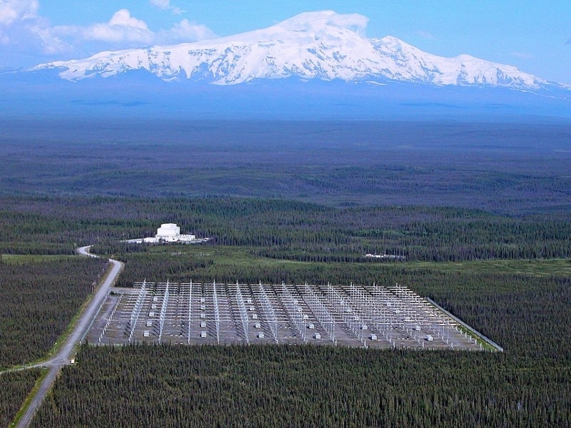
    A HAARP ?
    40°24'16.32"N
    93°38'12.46"E
    [IMG][/IMG]
    https://www.google.co.uk/search?q=ha...4h4Wl2IwaLM%3A
    Above link to see images of actual HAARP


    Another Vast Pattern in the sand ?
    40°27'5.58"N
    93°44'30.86"E

    I looked at one area, then hours had gone by, just looking around Google Earth, very addictive o.0
    Such a vast landscape and mostly barren .
    Last edited by Sunny-side-up; 28th October 2016 at 15:08.
    I'm a simple easy going guy that is very upset/sad with the worlds hidden controllers!
    We need LEADERS who bat from the HEART!
    Rise up above them Dark evil doers, not within anger but with LOVE

  2. The Following 11 Users Say Thank You to Sunny-side-up For This Post:

    avid (29th October 2016), Flash (29th October 2016), fourty-two (28th October 2016), Foxie Loxie (8th February 2018), Inversion (28th October 2016), Nasu (28th October 2016), Reinhard (28th October 2016), Savannah (28th October 2016), toppy (28th October 2016), vano915 (30th October 2016), wnlight (28th October 2016)

  3. Link to Post #2
    Ecuador Honored, Retired Member. Warren passed on 2 July, 2020.
    Join Date
    28th March 2014
    Location
    Cuenca, Ecuador
    Age
    80
    Posts
    953
    Thanks
    5,175
    Thanked 5,540 times in 864 posts

    Default Re: Google Earth China 'The Pattern' and more a HAARP?

    Sure looks like another HAARP. Thanks for pointing out these interesting views out in the desert of China.

  4. The Following 6 Users Say Thank You to wnlight For This Post:

    avid (29th October 2016), Bill Ryan (28th October 2016), Foxie Loxie (8th February 2018), Nasu (28th October 2016), Sunny-side-up (28th October 2016), toppy (28th October 2016)

  5. Link to Post #3
    Unsubscribed
    Join Date
    23rd June 2013
    Location
    North America
    Age
    72
    Posts
    6,884
    Thanks
    12,723
    Thanked 29,293 times in 6,140 posts

    Default Re: Google Earth China 'The Pattern' and more a HAARP?

    One can go to the "Haarp" site at those coordinates, and scroll the time slider (click on the date located at the bottom left of the google earth image), and scroll the date back to 5/29/2005. At that point it is just prior to the building of the 'whatever'. This is the image from that date.. Supplies to be used for the building of "it"? Notice there appears to be supplies which were there, and now are "missing", but don't appear to be used to build the "array".. where did they go, underground? Didn't seem to see a power system to power up such an array, in one of the buildings? or undergound? These types of "arrays" can be used for over-the-horizon radar also, not just high altitude ionospheric heating..


    (right click on the image, do a SAVE-AS and then you can expand the view to look at the finer details present)

  6. Link to Post #4
    UK Avalon Member Nick Matkin's Avatar
    Join Date
    17th March 2012
    Posts
    1,674
    Thanks
    1,615
    Thanked 5,742 times in 1,499 posts

    Default Re: Google Earth China 'The Pattern' and more a HAARP?

    Could it be tropo weather radar like the one in Aberystwyth and Uist - both frequently accused of being 'HAARP slaves"?

    Or maybe a phased array for China Radio International?

  7. The Following 7 Users Say Thank You to Nick Matkin For This Post:

    avid (29th October 2016), Bob (28th October 2016), Foxie Loxie (8th February 2018), joeecho (28th October 2016), Nasu (28th October 2016), Sunny-side-up (28th October 2016), toppy (28th October 2016)

  8. Link to Post #5
    Unsubscribed
    Join Date
    23rd June 2013
    Location
    North America
    Age
    72
    Posts
    6,884
    Thanks
    12,723
    Thanked 29,293 times in 6,140 posts

    Default Re: Google Earth China 'The Pattern' and more a HAARP?

    Here is a closeup of that site (available by using the date slider for the images) after they build whatever.. It is from 12/28/2010 - one can see the array's very clearly in this image, plus there are many more apparent antenna's in groups of 3 surrounding the main arrays. Just a FYI, 3 antenna minimum are used for properly phasing and directing low frequency signals.

    This facility then appears to be a highly steerable massive array covering numerous frequencies.

    The image from 12/28/2010 has good contrast allowing one to be able to view much of the surrounding area too, seeing many more small buildings, and possibly the entry guard house on one of the main roads going in.


    what a great find !! @Sunny-side-up

  9. Link to Post #6
    UK Avalon Member Sunny-side-up's Avatar
    Join Date
    4th April 2013
    Location
    Between here & there
    Age
    64
    Posts
    4,240
    Thanks
    46,713
    Thanked 21,123 times in 3,951 posts

    Default Re: Google Earth China 'The Pattern' and more a HAARP?

    Thanks Bob and all for your reply.

    The range of land from my Southern Google Earth Bookmark to the Northern one is a very strange area.
    Those massive geometric patterns are a puzzle. The area is very barren yet has so many tracks and anomalies all over it.
    Easy to have hidden DUMBS out there or just about anything I guess.

    The HAARP type installation is connected to a few road one of which leads off S-E from a little building.
    Follow it and it goes on for about 7.29 miles (As the Crow flys) to a another small building in the middle of nowhere?
    End of the HAARP rd?

    40°18'4.05"N
    93°35'54.02"E

    Just above this road ending the rd goes through what looks like an ancient raised wall?
    HAARP rd and a raised wall?
    I'm a simple easy going guy that is very upset/sad with the worlds hidden controllers!
    We need LEADERS who bat from the HEART!
    Rise up above them Dark evil doers, not within anger but with LOVE

  10. The Following 2 Users Say Thank You to Sunny-side-up For This Post:

    Bob (28th October 2016), Foxie Loxie (8th February 2018)

  11. Link to Post #7
    UK Avalon Founder Bill Ryan's Avatar
    Join Date
    7th February 2010
    Location
    Ecuador
    Posts
    34,400
    Thanks
    211,200
    Thanked 459,448 times in 32,921 posts

    Default Re: Google Earth China 'The Pattern' and more a HAARP?

    .
    As a neutral post, and for reference, this is what the Alaskan HAARP looks like:


    Click here for a large, high-resolution image:
    http://arrl.org/images/view/News/HAARP-3.jpg

  12. The Following 7 Users Say Thank You to Bill Ryan For This Post:

    Art (28th October 2016), avid (29th October 2016), Bob (28th October 2016), Foxie Loxie (8th February 2018), gaiagirl (29th October 2016), Sunny-side-up (29th October 2016), vano915 (30th October 2016)

  13. Link to Post #8
    Unsubscribed
    Join Date
    23rd June 2013
    Location
    North America
    Age
    72
    Posts
    6,884
    Thanks
    12,723
    Thanked 29,293 times in 6,140 posts

    Default Re: Google Earth China 'The Pattern' and more a HAARP?

    Hi @Sunny-side-up and the group. It certainly has gotten me looking around the coordinates that you found


    I took a close look using the historical time slider of Google Earth, to track back before the pattern was not there, and found what looked like heavy construction equipment. I have 3 time sequence images based on right when the construction equipment was starting in that area.

    It looks like they had driven over that area first. Maybe staked it out, took mineral samples, and then did some sort of surface strip mining high concentrations (??) maybe of something.. I think it odd that only precise "very tight road width channels" were cut.

    The depth doesn't appear to be very deep, and for some sort of "strip mining" it just seems to me, one would take a lot of the associated rock (over-burden) and not do such a gridwork.. Very odd...

    The last image in the sequence shows the erosion over time. Anyone in mining figure out what was being done here?


    Fascinating spots, and certainly got me using my google earth time slider ! Great hunting by Satellite !!

  14. Link to Post #9
    UK Avalon Member Sunny-side-up's Avatar
    Join Date
    4th April 2013
    Location
    Between here & there
    Age
    64
    Posts
    4,240
    Thanks
    46,713
    Thanked 21,123 times in 3,951 posts

    Default Re: Google Earth China 'The Pattern' and more a HAARP?

    I agree with you Bob. I would expect surface strip mining to be more like this square of land at:

    Vast square of land surface striped clean ?
    40°27'22.47"N
    93°22'12.19"E
    (Hmm? My Photobucket is not connecting any-more lol )

    But even then why keep it perfectly square?
    I think this square was done to erase/remove/hide something?
    Another thing, there are no 'Slag' waste piles anywhere?

    The area of pattern lines you looked at are random in layout as compared to the other pattern I posted. These random lines looks like a patched-up area, By patched-up I mean, it's like cracks have been followed and filled in to strengthen? Like cracks in a wall plaster!
    I know that's not the answer but it dose remind of it.

    All very strange ha?

    This connects to the HAARP thing,
    40°24'59.27"N
    93°35'8.64"E
    Looks like a layout of short poles, each with a truck parked next to it. A new HAARP thing being worked on?

    By the way, the HAARP thing is connected by road to the 'Striped-Square' and the 'Airfield' area.

    There has been a hell of a lot of mining going on. If you look at the most of the river beds and or paths of water flow, they are pot-marked with digging.

    About the 'Airfield':

    One 'Fighter on a pad at:
    40°28'9.00"N
    93°30'43.77"E
    There is a taxiway leading back to the runway, but doesn't look useable any-more, too rough.

    On a side note:
    A while back I reported a UFO that was following behind and below a commercial 7373 . Said UFO pivoted on it's right wing tip and went off back towards London centrer.
    At the time I thought the craft was 'Anti-gravity' because of the way it turned (no banking or tilting etc)

    Well that fighter at the airfield is parked over a wing shape, that wing shape is exactly the shape of the UFO-Wing craft I had seen. Just a side note

    Looking around Google Earth and satellite images is very addictive

    Much more to be found around this area of China me thinks.
    I'm a simple easy going guy that is very upset/sad with the worlds hidden controllers!
    We need LEADERS who bat from the HEART!
    Rise up above them Dark evil doers, not within anger but with LOVE

  15. The Following 2 Users Say Thank You to Sunny-side-up For This Post:

    Bob (8th February 2018), Foxie Loxie (8th February 2018)

  16. Link to Post #10
    UK Avalon Member Sunny-side-up's Avatar
    Join Date
    4th April 2013
    Location
    Between here & there
    Age
    64
    Posts
    4,240
    Thanks
    46,713
    Thanked 21,123 times in 3,951 posts

    Default Re: Google Earth China 'The Pattern' and more a HAARP?

    More strangeness in the desert?

    Google Earth Link 43°04'51.75"N/92°48'26.85"E


    Quote David Carmony
    6 months ago
    If I remember correctly (ex USAF Crash Fire Rescue) NASA had an emergency facility in the Gobi dessert for the space shuttle. If an in flight emergency occurred shortly after take off, there were several emergency landing options in various locations around the world. They could be utilized for emergency landings as well, if they had to get back down for whatever reason and weather made their normal recovery base inaccessible. This may account for the runways being placed at odd angles. If they are coming down fast and unable to maneuver the aircraft, you would need to have options. Not 100% on any of that, but I vaguely remember (25 yrs ago) an alternate Gobi site being tied to the shuttle. Lack of wear would also be explained by this theory. Hope that helps!
    I'm a simple easy going guy that is very upset/sad with the worlds hidden controllers!
    We need LEADERS who bat from the HEART!
    Rise up above them Dark evil doers, not within anger but with LOVE

  17. The Following 2 Users Say Thank You to Sunny-side-up For This Post:

    avid (8th February 2018), Foxie Loxie (8th February 2018)

  18. Link to Post #11
    UK Avalon Member avid's Avatar
    Join Date
    19th March 2010
    Location
    NW UK
    Language
    English
    Posts
    2,896
    Thanks
    59,345
    Thanked 15,782 times in 2,666 posts

    Default Re: Google Earth China 'The Pattern' and more a HAARP?

    Check all comments on video, seems like either some satellite configuration, or a mad driving school with military trucks doing figures of 8!
    The love you withhold is the pain that you carry
    and er..
    "Chariots of the Globs" (apols to Fat Freddy's Cat)

  19. The Following 3 Users Say Thank You to avid For This Post:

    Bob (8th February 2018), Foxie Loxie (8th February 2018), Sunny-side-up (8th February 2018)

  20. Link to Post #12
    UK Avalon Member Sunny-side-up's Avatar
    Join Date
    4th April 2013
    Location
    Between here & there
    Age
    64
    Posts
    4,240
    Thanks
    46,713
    Thanked 21,123 times in 3,951 posts

    Default Re: Google Earth China 'The Pattern' and more a HAARP?

    Quote Posted by avid (here)
    Check all comments on video, seems like either some satellite configuration, or a mad driving school with military trucks doing figures of 8!
    Yes they are strange?
    Most are perfect looking circles.
    I'm a simple easy going guy that is very upset/sad with the worlds hidden controllers!
    We need LEADERS who bat from the HEART!
    Rise up above them Dark evil doers, not within anger but with LOVE

  21. The Following User Says Thank You to Sunny-side-up For This Post:

    Foxie Loxie (8th February 2018)

  22. Link to Post #13
    UK Avalon Member Nick Matkin's Avatar
    Join Date
    17th March 2012
    Posts
    1,674
    Thanks
    1,615
    Thanked 5,742 times in 1,499 posts

    Default Re: Google Earth China 'The Pattern' and more a HAARP?

    The figure of eight look like some sort of aircraft turning areas. I'm no aviation expert (those out there who are please feel free to contribute), but they are similar to ones in the UK, and probably very common on military air bases.


  23. The Following 3 Users Say Thank You to Nick Matkin For This Post:

    avid (8th February 2018), Foxie Loxie (8th February 2018), Sunny-side-up (11th September 2018)

  24. Link to Post #14
    United States Avalon Member Seabreeze's Avatar
    Join Date
    14th December 2018
    Location
    Terra
    Language
    English
    Age
    63
    Posts
    737
    Thanks
    582
    Thanked 2,293 times in 594 posts

    Default Re: Google Earth China 'The Pattern' and more a HAARP?

    I don`t know....but some people call this portable haarp....


    https://en.wikipedia.org/wiki/Sea-based_X-band_Radar

    https://www.youtube.com/watch?v=NR4a65mNinU

    The SBX also has been accused of causing garage door malfunctions, affecting pacemakers — even altering the weather, officials said.

    There are currently 22,000 modules installed on the base. Each module has one transmit-receive feed horn and one auxiliary receive feed horn for a second polarization, totaling 44,000 feedhorns. The base is roughly 2/3 populated, with space for installation of additional modules. The current modules are concentrated toward the center to minimize grating lobes. This configuration allows it to support the very-long-range target discrimination and tracking that GMD's midcourse segment requires. The radar is never pointed at land, for the safety of the inhabitants.[2]


    source...

    https://web.archive.org/web/20141217...l?id=114443724

    .
    Last edited by Seabreeze; 2nd December 2019 at 02:29.

+ Reply to Thread

Posting Permissions

  • You may not post new threads
  • You may not post replies
  • You may not post attachments
  • You may not edit your posts