+ Reply to Thread
Results 1 to 16 of 16

Thread: Africa is way bigger than I thought.

  1. Link to Post #1
    UK Avalon Member Le Chat's Avatar
    Join Date
    22nd May 2019
    Posts
    588
    Thanks
    2,685
    Thanked 4,374 times in 575 posts

    Default Africa is way bigger than I thought.

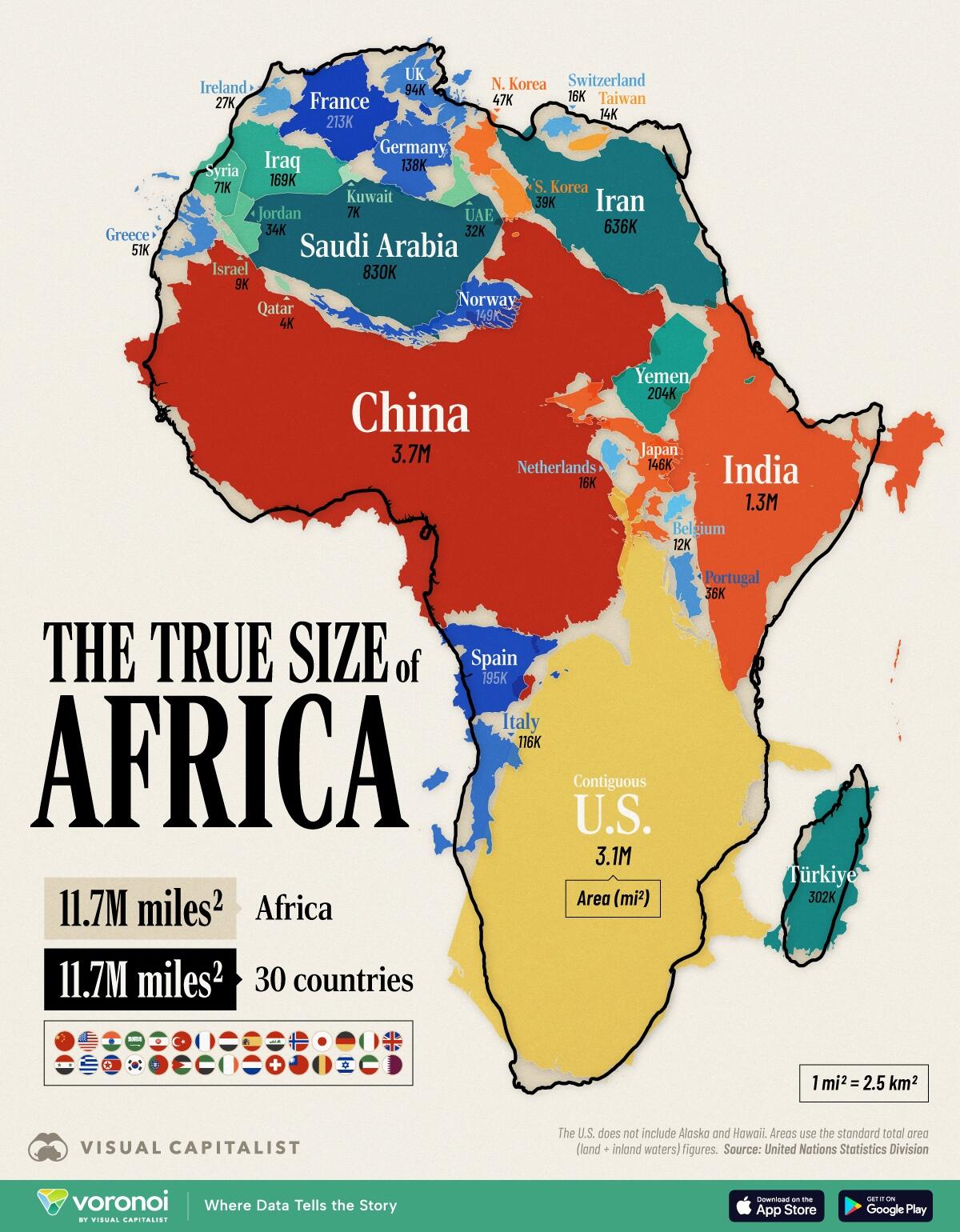
    The Mercator projection of the world is so out of proportion.

    Just look at all the countries that can fit inside...

    Click image for larger version

Name:	Screenshot 2025-05-26 at 15.29.07.jpg
Views:	90
Size:	234.1 KB
ID:	55214

  2. The Following 26 Users Say Thank You to Le Chat For This Post:

    Arcturian108 (26th May 2025), arjunaloka_official (27th May 2025), Bill Ryan (26th May 2025), bobme (27th May 2025), Brigantia (26th May 2025), Casey Claar (26th May 2025), Ewan (14th October 2025), ExomatrixTV (27th May 2025), grapevine (26th May 2025), Harmony (27th May 2025), Inversion (26th May 2025), Ioneo (26th May 2025), Jamie (27th May 2025), Johnnycomelately (26th May 2025), Kryztian (26th May 2025), Maknocktomb (27th May 2025), Mark (Star Mariner) (26th May 2025), Michi (27th May 2025), onevoice (26th May 2025), Orph (26th May 2025), pounamuknight (14th October 2025), rgray222 (27th May 2025), Sunny-side-up (27th May 2025), Tintin (26th May 2025), Yoda (26th May 2025)

  3. Link to Post #2
    Canada Avalon Member Johnnycomelately's Avatar
    Join Date
    14th January 2022
    Location
    Edmonton, Alberta, Canada
    Language
    English
    Age
    66
    Posts
    1,672
    Thanks
    23,513
    Thanked 10,547 times in 1,650 posts

    Default Re: Africa is way bigger than I thought.

    James A. Mitchener, in his novel The Covenant, tells a gripping story of a long long walk up and back through old times Africa. Might have happened irl, we’ve always been wanderers.

    The country South Africa is drawing attention now, MSM is saying no “white genocide”.

    Please see the Serpentza YT chan, dude who grew up there and wouldn’t move back, Winston. He talks about white farmer murders and worse.

  4. The Following 13 Users Say Thank You to Johnnycomelately For This Post:

    Bill Ryan (26th May 2025), Brigantia (26th May 2025), Casey Claar (26th May 2025), Ewan (14th October 2025), ExomatrixTV (27th May 2025), grapevine (26th May 2025), Harmony (27th May 2025), Inversion (26th May 2025), Le Chat (26th May 2025), pounamuknight (14th October 2025), Tintin (26th May 2025), wondering (26th May 2025), Yoda (26th May 2025)

  5. Link to Post #3
    UK Avalon Founder Bill Ryan's Avatar
    Join Date
    7th February 2010
    Location
    Ecuador
    Posts
    38,472
    Thanks
    273,113
    Thanked 512,804 times in 37,010 posts

    Default Re: Africa is way bigger than I thought.

    Re the size of Africa (and everything else!), this wonderful clip from The West Wing says it all. (And it's not just a joke. )


  6. The Following 22 Users Say Thank You to Bill Ryan For This Post:

    arjunaloka_official (27th May 2025), Brigantia (26th May 2025), Casey Claar (26th May 2025), Ewan (14th October 2025), ExomatrixTV (27th May 2025), grapevine (28th May 2025), Harmony (27th May 2025), Heart to heart (26th May 2025), Inversion (26th May 2025), Ioneo (26th May 2025), Jamie (27th May 2025), Le Chat (26th May 2025), Mark (Star Mariner) (27th May 2025), onevoice (26th May 2025), pounamuknight (14th October 2025), rgray222 (27th May 2025), Sunny-side-up (27th May 2025), Tintin (27th May 2025), Vicus (26th May 2025), White Cedar (14th October 2025), wondering (26th May 2025), Yoda (26th May 2025)

  7. Link to Post #4
    United States Avalon Member Casey Claar's Avatar
    Join Date
    26th April 2022
    Location
    San Diego, CA
    Language
    English
    Age
    60
    Posts
    1,216
    Thanks
    6,796
    Thanked 11,604 times in 1,215 posts

    Default Re: Africa is way bigger than I thought.

    Oh. my. god.

    I have heard of this being the case, but have not yet ever really looked into the fullness of it.

    So is there a map that has been drawn that you ( Bill ) feel is a more accurate representation of the continents and our planet?

    Please share. And, also, where can I see more of the above clip? does more get explained from where the clips leaves off?

    Thank you thank you
    "Love is what is left when you let go of everything you no longer need." —Raj

  8. The Following 12 Users Say Thank You to Casey Claar For This Post:

    Bill Ryan (26th May 2025), Brigantia (26th May 2025), Ewan (14th October 2025), grapevine (28th May 2025), Harmony (27th May 2025), Heart to heart (26th May 2025), Inversion (26th May 2025), Le Chat (26th May 2025), Sunny-side-up (27th May 2025), Tintin (27th May 2025), wondering (26th May 2025), Yoda (26th May 2025)

  9. Link to Post #5
    UK Avalon Member Le Chat's Avatar
    Join Date
    22nd May 2019
    Posts
    588
    Thanks
    2,685
    Thanked 4,374 times in 575 posts

    Default Re: Africa is way bigger than I thought.

    Hi Casey,
    This may help you understand that there are very many map interpretations...


  10. The Following 12 Users Say Thank You to Le Chat For This Post:

    Bill Ryan (26th May 2025), Casey Claar (27th May 2025), Ewan (14th October 2025), grapevine (28th May 2025), Harmony (27th May 2025), Inversion (26th May 2025), Ioneo (26th May 2025), Sunny-side-up (27th May 2025), Tintin (27th May 2025), Vicus (26th May 2025), wondering (26th May 2025), Yoda (26th May 2025)

  11. Link to Post #6
    UK Avalon Founder Bill Ryan's Avatar
    Join Date
    7th February 2010
    Location
    Ecuador
    Posts
    38,472
    Thanks
    273,113
    Thanked 512,804 times in 37,010 posts

    Default Re: Africa is way bigger than I thought.

    Quote Posted by Casey Claar (here)
    Oh. my. god.

    I have heard of this being the case, but have not yet ever really looked into the fullness of it.

    So is there a map that has been drawn that you ( Bill ) feel is a more accurate representation of the continents and our planet?

    Please share. And, also, where can I see more of the above clip? does more get explained from where the clips leaves off?

    Thank you thank you
    That clip was the entire thing on that topic in that particular West Wing episode. (I wish there'd have been more, too! It was just a small part of Season 2 Episode 16.)

    (But if you've never seen them, all the first 4 seasons of The West Wing were acclaimed masterpieces: funny, profound, fast-paced, and beautifully scripted by Aaron Sorkin. Highly highly recommended. Some critics maintain to this day it's the best series ever to have been on TV.)

    But here's a formal page all about the Gall-Peters projection: (It's a real thing!)
    Peters Projection Map: Everything you ever Wanted to Know

    The Peters projection map is one of the more famous projections. We answer the most common questions about the Gall-Peters projection.


    The Gall-Peters projection map, also known as the Peters map, is a cylindrical projection of the world. It offers a representation of the nations in their true proportion to one another, which provides a helpful corrective to the distortions of traditional maps for countries to fit on a flat surface. In this map, the regions near the equator are stretched out, and the polar regions are compressed, leading to a unique and visually striking representation of the world.

    One of the most notable features of the Gall-Peters projection style is that it emphasizes the southern hemisphere, which needs to be addressed in traditional maps. The Gall-Peters map shows countries such as Australia and Africa in their actual size, which helps to challenge the notion of a "north-centric" worldview. The map also encourages us to think about the global distribution of wealth, resources, and political power, by accurately representing the size and significance of countries in a new light.

    If you've ever gazed at projections like the Robinson projection and felt frustrated by how countries are stretched or squished to fit on a flat surface, then the Gall-Peters projection is the map for you. The Gall-Peters projection is a powerful map type that fosters a greater understanding of our world and a challenge to traditional maps that often perpetuate cultural and geographical biases. Whether you're a student, a teacher, or a curious map enthusiast, the Gall-Peters projection will inspire a new appreciation for our planet's incredible diversity and complexity.

    How The Peters World Map Impacted Cartography

    In 1855, clergyman James Gall unveiled the Gall-Peters projection at the British Association for the Advancement of Science's meeting in Glasgow, initially naming it the "orthographic." He formally published his findings in 1885 in the Scottish Geographical Magazine. Years later, German historian Arno Peters called a press conference to announce his spin on the projection. Peters presented the "Peters world map" in 1973. It wasn't until 1986 when Arthur H. Robinson published a pamphlet with the American Cartographic Association, that the name "Gall-Peters projection" was coined. Throughout the years, the map has been referred to by various names, including "Gall orthographic" and "Gall's orthographic." But today, most Peters supporters refer to it as the "Peters projection." Nevertheless, in recent years, the name "Gall-Peters" has become the more commonly used moniker for this iconic map.

    The Gall-Peters map shook the status quo of the world of cartography with its bold vision of a more equitable representation of the planet. Born out of a desire to challenge the distorted shape of the Earth perpetuated by the dominant Mercator map, Arno Peters sought to create a new map superior in its portrayal of proportions and sizes of the countries.

    With the Gall-Peters projection, Peters aimed to rectify this issue through an equal-area projection of countries. This new map represented a revolutionary shift in cartography and sparked a heated debate in the mapping community. Some lauded it as a more accurate representation of the world, while others criticized its lack of conformity to traditional map-making practices.

    Today, the Gall-Peters Projection map's importance goes far beyond questions of cartographic accuracy. It stands as a symbol of the power of representation and the importance of considering the cultural and political implications of how we depict the world. Its impact continues to be felt, inspiring new generations to think differently about how they perceive and understand our planet. The Gall-Peters Projection map is a daring work of the German historian Arno Peters, a bold statement of purpose, and a testament to the enduring power of maps to shape our understanding of the world.

    Pros and Cons of the Peters Projection Map

    Picture a map of the world. What do you see? Latitude and longitude lines? Continents, oceans, and countries? But what if that map does not accurately represent our world? The Peters Projection is a map that does just that - it challenges our view of the world. Some of the benefits of using this projection include the following:

    Pros:
    1. Area accuracies: The Peters Projection is a representation of the world that prioritizes the accuracy of land masses' areas over their shapes. This makes the continents appear in their relative size, which is often distorted in traditional map projections.
    2. Perception of equality: It also promotes equal area representation of different regions, giving a voice to third world countries and other marginalized areas.
    3. Decolonization of a variety of maps: Peters' projection map was designed to challenge the Eurocentric view of the world often portrayed in traditional map projections, which tends to diminish the importance of regions other than Europe and North America.
    However, the Peters Projection also has some limitations.

    Cons:
    1. Distorted Shapes: While it preserves the area of land masses, it still does not preserve the shapes of countries, making it challenging to use for navigational purposes. It also has some distortion near the poles.
    2. Limited Use: Peters Projection needs to be better suited for large-scale maps, making it less useful for many practical applications.
    3. Controversy: While the intent behind Peters' Projection was to challenge traditional Eurocentric views, it has also been criticized as a political statement, making it vulnerable to falling into disuse as a tool for education and mapping.
    Despite its flaws, the Peters Projection remains a valuable tool for changing how we see the world. It offers a new perspective that breaks away from the Eurocentric view that has dominated maps for centuries. By representing the regions' land area accurately, it challenges our traditional beliefs and makes us likely to see the world in a new light.
    So, the next time you look at a world reference map, think about the Peters Projection and what it represents - a world where all regions are given equal importance and representation.

    Peters Map vs. Mercator Map Projection

    The Peters projections and Mercator projections have been the subject of much debate among geographers and cartographers for decades. The Peters projection is known for its area accuracy - no countries incorrectly in proportion to one another. On the other hand, the Mercator projection map by Gerardus Mercator has been around since it was developed in 1569, preserving angles and shapes with grace and ease. But, it has its flaws. It created a skewed world perspective by exaggerating the size of high latitude countries. For example, Greenland was represented as the same size as Africa when it was not.

    The Mercator projection, however, has the advantage of preserving angles and shapes, making it useful in the 16th century for navigational use and presenting directional information. This projection is still widely used in classrooms, on websites, and many wall maps. However, it's noteworthy that the Peters projection map is the map that UNESCO promotes.

    In 1989, seven North American geographical powerhouses banded together to give the boot to all rectangle-shaped world maps by adopting a resolution, including the Mercator and Gall-Peters projections.

    The controversies surrounding these two projections highlight cartographers' difficult balancing act when creating maps. While it is essential to represent the size of countries accurately, it is also necessary to consider the intended use of the map and the preservation of angles and shapes. Ultimately, the choice between the Mercator and Peters projections depends on the specific needs of the user and the information they want to convey.

  12. The Following 12 Users Say Thank You to Bill Ryan For This Post:

    Casey Claar (26th May 2025), Ewan (14th October 2025), ExomatrixTV (28th May 2025), grapevine (28th May 2025), Harmony (27th May 2025), Inversion (26th May 2025), Jamie (27th May 2025), Michi (27th May 2025), Sunny-side-up (27th May 2025), Vicus (26th May 2025), wondering (26th May 2025), Yoda (26th May 2025)

  13. Link to Post #7
    United States Avalon Member Casey Claar's Avatar
    Join Date
    26th April 2022
    Location
    San Diego, CA
    Language
    English
    Age
    60
    Posts
    1,216
    Thanks
    6,796
    Thanked 11,604 times in 1,215 posts

    Default Re: Africa is way bigger than I thought.

    Thank you, Bill!.. this is great, I will have a closer look as time allows.
    "Love is what is left when you let go of everything you no longer need." —Raj

  14. The Following 5 Users Say Thank You to Casey Claar For This Post:

    Bill Ryan (27th May 2025), Harmony (27th May 2025), Inversion (26th May 2025), Kryztian (27th May 2025), Yoda (27th May 2025)

  15. Link to Post #8
    Palestinian Territory Avalon Member Kryztian's Avatar
    Join Date
    16th September 2012
    Language
    English
    Posts
    4,319
    Thanks
    27,930
    Thanked 38,048 times in 4,258 posts

    Default Re: Africa is way bigger than I thought.

    There is a 1992 British TV documentary "Pole to Pole" staring Michael Palin (of Monty Python fame, no relation to the crazy woman of Wasilla, Alaska) about traversing the globe longitudinally. Much of that distance is covered along the African continent and more than half of it's eight parts are filmed there.

    Somewhere during episode 3 Palin arrives in Egypt and gets to Cape Town, South Africa at the end of episode 7.

    Episode 4: At Wadi Halfa, Palin travels by train to the Sudanese capital of Khartoum, where he visits a British sports club for food and a game, and witnesses a Muslim Sufi ceremony. Forced to circumnavigate the south of the country due to ongoing fighting, Palin and his crew head for Ethiopia with an Eritrean company, dealing with poor road conditions, and entering border territory made unsafe by the conclusion of the Ethiopian Civil War, in order to reach the town of Gedaref.


    Episode 7: In Zambia, Palin encounters a witch doctor and jubliant citizens, before spending a day at the Shiwa Ngandu estate. Travelling to the Victoria Falls, he tries whitewater rafting on the Zambezi River, before heading to Zimbabwe, visiting the grave of Cecil Rhodes, meet members of a bowlers club, and enjoy a local nightclub. Eventually, Palin reaches South Africa, exploring the gold mining industry of Johannesburg, before pressing on for Cape Town aboard the Blue Train, where bad news awaits his arrival.

    Going from the northern most point in Africa, in Tunisia, at 37 degrees North latitude, to the southernmost point in South Africa, at 35 degrees South, one traverses 72 degrees of latitude!

  16. The Following 9 Users Say Thank You to Kryztian For This Post:

    Bill Ryan (27th May 2025), Casey Claar (27th May 2025), East Sun (13th October 2025), ExomatrixTV (28th May 2025), Harmony (27th May 2025), Inversion (26th May 2025), rgray222 (28th May 2025), Tintin (27th May 2025), Yoda (27th May 2025)

  17. Link to Post #9
    Administrator Mark (Star Mariner)'s Avatar
    Join Date
    15th November 2011
    Language
    English
    Posts
    6,645
    Thanks
    42,686
    Thanked 56,026 times in 6,556 posts

    Default Re: Africa is way bigger than I thought.

    A quick-look reference for the actual size of countries.

    Click image for larger version

Name:	country-size-map.jog.jpg
Views:	29
Size:	139.1 KB
ID:	55218

    Also, an interactive map. Enter the name of the country in the box, then drag it around to compare true size.
    https://thetruesize.com/?#
    "When the power of love overcomes the love of power the world will know peace."
    ~ Jimi Hendrix

  18. The Following 15 Users Say Thank You to Mark (Star Mariner) For This Post:

    arjunaloka_official (27th May 2025), Bill Ryan (27th May 2025), Casey Claar (27th May 2025), Ewan (14th October 2025), ExomatrixTV (28th May 2025), halcyon026 (27th May 2025), Harmony (27th May 2025), Inversion (28th May 2025), Kryztian (27th May 2025), Michi (27th May 2025), Orph (27th May 2025), rgray222 (28th May 2025), Tintin (27th May 2025), Vicus (14th October 2025), Yoda (27th May 2025)

  19. Link to Post #10
    United States Avalon Member Casey Claar's Avatar
    Join Date
    26th April 2022
    Location
    San Diego, CA
    Language
    English
    Age
    60
    Posts
    1,216
    Thanks
    6,796
    Thanked 11,604 times in 1,215 posts

    Default Re: Africa is way bigger than I thought.

    Quote Posted by Mark (Star Mariner) (here)
    A quick-look reference for the actual size of countries.


    Also, an interactive map. Enter the name of the country in the box, then drag it around to compare true size.
    https://thetruesize.com/?#
    This is quite sobering, isn't it? Wow.
    Last edited by Bill Ryan; 27th May 2025 at 18:19. Reason: embedded the image in the quoted post
    "Love is what is left when you let go of everything you no longer need." —Raj

  20. The Following 8 Users Say Thank You to Casey Claar For This Post:

    Bill Ryan (27th May 2025), Ewan (14th October 2025), ExomatrixTV (28th May 2025), Harmony (28th May 2025), Inversion (28th May 2025), Mark (Star Mariner) (27th May 2025), rgray222 (28th May 2025), Yoda (27th May 2025)

  21. Link to Post #11
    Belgium Avalon Member
    Join Date
    6th April 2014
    Location
    France
    Language
    Dutch, French
    Age
    75
    Posts
    1,212
    Thanks
    15,200
    Thanked 9,877 times in 1,196 posts

    Default Re: Africa is way bigger than I thought.

    In order to sweep away those imperialist and exceptionalist illusions, it suffices to buy a globe.

    People who believe in projections, Mercatorian or Freudian, are basically flat earth theorists.

  22. The Following 6 Users Say Thank You to Michel Leclerc For This Post:

    Bill Ryan (27th May 2025), Casey Claar (27th May 2025), Harmony (28th May 2025), Kryztian (28th May 2025), Vicus (14th October 2025), Yoda (27th May 2025)

  23. Link to Post #12
    Netherlands Avalon Member ExomatrixTV's Avatar
    Join Date
    23rd September 2011
    Location
    Netherlands
    Language
    English, Dutch, German, Limburgs
    Age
    59
    Posts
    29,477
    Thanks
    43,771
    Thanked 164,843 times in 27,489 posts

    Lightbulb Re: Africa is way bigger than I thought.

    • How BIG is Africa?
    No need to follow anyone, only consider broadening (y)our horizon of possibilities ...

  24. The Following 6 Users Say Thank You to ExomatrixTV For This Post:

    Bill Ryan (28th May 2025), Casey Claar (28th May 2025), Harmony (28th May 2025), Inversion (28th May 2025), rgray222 (28th May 2025), Yoda (28th May 2025)

  25. Link to Post #13
    UK Avalon Founder Bill Ryan's Avatar
    Join Date
    7th February 2010
    Location
    Ecuador
    Posts
    38,472
    Thanks
    273,113
    Thanked 512,804 times in 37,010 posts

    Default Re: Africa is way bigger than I thought.

    A new piece on Zero Hedge:

    https://www.zerohedge.com/geopolitic...ents-true-size

    How Many Countries fit in Africa? Visualizing the Continent's True Size

    Africa is vast.

    So vast that its full scale can be hard to grasp by looking at most world maps.

    The graphic below, via Visual Capitalist's Pallavi Rao, solves this by combining individual countries inside the continent’s area, showing that Africa’s landmass is on par with the (contiguous) U.S., China, India, and much of Western Europe combined.


    Data for this visualization comes from UN Statistics Division and total area (land + inland waters) was used for this comparison.

    Africa’s Area in Raw Numbers

    At 11.7 million mi² (30.4 million km²), Africa is the world’s second-largest continent after Asia.

    Put another way, it easily contains the contiguous U.S. (3.1M mi² / 8.1M km²) and China (3.7M mi² / 9.6M km² ) with room to spare.


    Add India’s 1.3M mi² (3.3M km²) and we’re still not close to filling the continent’s footprint.

    In fact, it takes a total of 30 countries together—shown in the graphic above —to equal Africa’s total area, underscoring how massive the continent is in absolute terms.

    Of course, country selection can change these numbers. If prioritizing Central and South American countries instead (like Mexico and Argentina,) the comparison could reduce to 18 entities.

    Including Alaska and Hawaii would increase America’s footprint by 700,000 mi² (1.8M km²).

    Why Your Wall Map Gets Africa Wrong

    Many of us grew up looking at wall maps that use the Mercator projection.

    This 16th-century design keeps straight lines for navigation but dramatically enlarges regions near the poles and compresses those near the equator.

    Africa, which straddles the equator, is one of the biggest victims of this distortion.
    That discrepancy fuels common misconceptions about just how expansive Africa really is.

    African Union Calls For Equal Projections Map

    The African Union has asked international organizations to stop using the Mercator projection.

    They say this size misrepresentation undermines the perceived global influence and importance of Africa and perpetuates stereotypes.

    For example, the frequent use of the Mercator map in educational settings and media can lead many to unconsciously imagine Europe and North America as disproportionately significant.

    Meanwhile Africa appears less substantial and “marginal.”

    The map above also drives home another point. When discussing global development, trade, or climate impacts, treating Africa as a single bloc overlooks the continent’s enormous spatial and cultural complexity.

  26. The Following 9 Users Say Thank You to Bill Ryan For This Post:

    Ewan (14th October 2025), grapevine (13th October 2025), Harmony (13th October 2025), jc71 (13th October 2025), kudzy (13th October 2025), leavesoftrees (14th October 2025), Orph (13th October 2025), skogvokter (14th October 2025), Yoda (13th October 2025)

  27. Link to Post #14
    Avalon Member Merkaba360's Avatar
    Join Date
    9th December 2010
    Location
    SE Asia
    Language
    English
    Age
    47
    Posts
    646
    Thanks
    2,646
    Thanked 3,690 times in 574 posts

    Default Re: Africa is way bigger than I thought.

    or just look at globes lol . Look at the green areas. South America looks the nicest for greenery + secure location. North America pretty good too. The green area of S. America is near the same size as the green area of Africa.

    Africa should be focused on a way to reverse the desert.

    Although if the sea rises, the Americas are affected quite a bit, I believe Africa less so, unless land masses change elevations from major shifts that remote viewers and others are seeing to possibly start in the 2030s and become huge changes by the 2040s.

  28. The Following 4 Users Say Thank You to Merkaba360 For This Post:

    Bill Ryan (14th October 2025), Ewan (14th October 2025), Harmony (14th October 2025), skogvokter (14th October 2025)

  29. Link to Post #15
    Scotland Avalon Member Ewan's Avatar
    Join Date
    24th February 2015
    Location
    Ireland
    Age
    63
    Posts
    2,608
    Thanks
    76,292
    Thanked 21,007 times in 2,562 posts

    Default Re: Africa is way bigger than I thought.

    Quote Posted by Casey Claar (here)
    Oh. my. god.

    I have heard of this being the case, but have not yet ever really looked into the fullness of it.

    So is there a map that has been drawn that you ( Bill ) feel is a more accurate representation of the continents and our planet?

    Please share. And, also, where can I see more of the above clip? does more get explained from where the clips leaves off?

    Thank you thank you
    There was a thread about this back in 2023 which you may like to look at. IMO it is not about Africa being bigger but the rest of the countries, (some much), smaller

    https://projectavalon.net/forum4/sho...rojection-map.

  30. The Following 3 Users Say Thank You to Ewan For This Post:

    Bill Ryan (14th October 2025), Harmony (14th October 2025), skogvokter (14th October 2025)

  31. Link to Post #16
    Avalon Member leavesoftrees's Avatar
    Join Date
    7th April 2010
    Posts
    598
    Thanks
    4,374
    Thanked 3,648 times in 536 posts

    Default Re: Africa is way bigger than I thought.

    Australia is not in the equation. According to this website Africa is 3.9 times bigger than Australia.

    Here's the website:

    https://www.mylifeelsewhere.com/country-size-comparison/africa/australia


    Last edited by Bill Ryan; 14th October 2025 at 11:54.

  32. The Following 4 Users Say Thank You to leavesoftrees For This Post:

    Bill Ryan (14th October 2025), Ewan (15th October 2025), Harmony (14th October 2025), skogvokter (14th October 2025)

+ Reply to Thread

Posting Permissions

  • You may not post new threads
  • You may not post replies
  • You may not post attachments
  • You may not edit your posts