-
14th February 2014 18:31
Link to Post #1
Erupting Volcano of Mount Kelud on Java island Indonesia
14 Feb 2014 Massive Volcanic Eruption Java Island Indonesia
Forcing evacuations of between 100,000-200,000 people, having already killed 3
The explosion was heard 125 miles away, 200 km.
Ash and grit fell to earth in towns and cities across the region, including Surabaya, Indonesia's second-largest city after Jakarta, with a population of about 3 million.
-
14th February 2014 18:45
Link to Post #2
Re: Erupting Volcano of Mount Kelud on Java island Indonesia
From Nature World News, Mount Kelud data
ref: http://www.natureworldnews.com/artic...h-blankets.htm
Mount Kelud erupted late Thursday on Indonesia's Java island, eruptions continuing into Friday.
Indonesia's National Disaster Mitigation Agency (BNPB) issued an evacuation warning about an hour before the volcano - which had been rumbling for days - erupted, for people living within 10 kilometers (6 miles) of Mt. Kelud.
Of the three that died, two people died of smoke inhalation and a third died from falling debris.
Mt Kelud is also a Strato-Volcano, similar to the one (Vesuvius) which destroyed Pompeii and Herculaneum. The strato-volcano Tungurahua in Ecuador has been erupting since about the 1st February. Similar gas clouds and pyroclastic flows of ash and debris were emitted. Scientists predict that the next eruption of Mount Vesuvius will be violent, having erupted last in 1944.
Stratovolcanoes are the world's most dangerous volcanoes.
-
14th February 2014 19:16
Link to Post #3
Re: Erupting Volcano of Mount Kelud on Java island Indonesia
"Indonesia has approximately 130 active volcanoes. Due to its population density and the fertile soils that volcanic slopes provide, hundreds of thousands of Indonesians live close to active volcanoes. They have learnt to live with the rumblings and frequently ignore orders to leave."
"The huge archipelago sits between the most active seismic region in the world, the Pacific Ring of Fire, an area where a large number of earthquakes and volcanic eruptions occur, and the Alpide Belt."
ref: http://www.independent.co.uk/news/wo...e-9128148.html - eruption in Indonesia
The Alpide Belt is among the most seismically active zones in the world. The Ring of Fire, or the circum-Pacific belt, is the world’s greatest earthquake belt, according to Live Science, because of fault lines running from Chile to Japan and Southeast Asia.
These fault lines are breaks in the plates of the Earth’s crust and are where earthquakes are likely to occur.
http://www.livescience.com/8823-indo...explained.html - Indonesia's Explosive Geology on the Ring of Fire
"Precariously located above the grinding and mashing of several tectonic plates, and ringed by a chain of fire-breathing volcanoes, the country's islands are located in one of the most volatile regions in the world. The eruption of a volcano and the shaking of a tsunami-generating earthquake this week is just one reminder of Indonesia's fiery foundation.
"As the world's largest archipelago — spread across 17,500 islands — Indonesia sits between the world's most active seismic region — the notorious Pacific Ring of Fire — and the world's second most active region — the Alpide belt. Being sandwiched between such seismicity has meant the islands experience some of the strongest earthquakes and most powerful volcanic eruptions known on Earth."
-
14th February 2014 19:21
Link to Post #4
Re: Erupting Volcano of Mount Kelud on Java island Indonesia
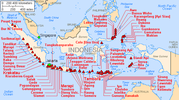
Both of Indonesia's most active volcanoes – Kelut and Mount Merapi (meaning "mountain of fire") – sit on Java Island.
And both have a history of explosive eruptions. Mount Merapi erupted today (Oct. 26), with preliminary reports of 100 people killed, according to the USGS. Merapi is located in central Java, roughly 310 miles (500 kilometers) southeast of the capital Jakarta.
Mount Merapi last erupted in 2006, killing two, but its violent history includes more than 1,300 killed in a 1930 eruption and possibly 70 killed in a 1994 eruption.
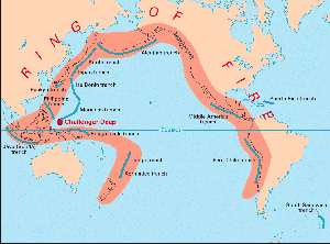
Other colossal volcanic eruptions that have occurred in Indonesia include the eruption of Krakatau, which reportedly generated the loudest sound ever heard in modern history when it exploded in 1883, killing 40,000 people. Krakatau is a volcanic island located between the islands of Java and Sumatra.
The Toba supervolcano located on the island of Sumatra, which erupted 70,000 years ago, was a global catastrophe, creating six years of volcanic winter.
ref: http://www.livescience.com/8823-indo...explained.html
Dr Steven Godby, an expert in natural hazards at Nottingham Trent University, said Kelud is regarded as one of the most dangerous volcanoes on Java because of its frequent eruptions and deadly 'lahars'.
"Lahar is an Indonesian term used to describe the hot or cold mixture of water, rock and ash that can flow down the slopes of a volcano or along river valleys", he said. "Kelud’s typically short but violent eruptions cause the ejection of water from a crater lake at its summit."
Last edited by Bob; 14th February 2014 at 19:24.
-
14th February 2014 19:53
Link to Post #5
Re: Erupting Volcano of Mount Kelud on Java island Indonesia
Map of Major Volcanoes of Indonesia
The volcanoes in Indonesia are among the most active of the Pacific Ring of Fire.
They are formed due to subduction zones of three main active tectonic plates namely the Eurasian Plate, Pacific Plate, and the Indo-Australian Plate.
Some of the volcanoes are notable for their eruptions, for instance, Krakatau* for its global effects in 1883, Lake Toba for its supervolcanic eruption estimated to have occurred 74,000 years ago that was responsible for six years of volcanic winter, and Mount Tambora for the most violent eruption in recorded history in 1815.
The eruption of Mount Tambora in 1815 caused wide spread harvest failures in Northern Europe, the Northeastern United States, and eastern Canada in 1816, which was known as the Year Without a Summer.
The most active volcanoes are Kelud and Mount Merapi on Java island which have been responsible for thousands of deaths in the region.
Since AD 1000, Kelud has erupted more than 30 times, of which the largest eruption was at scale 5 on the Volcanic Explosivity Index, while Merapi has erupted more than 80 times.
Krakatoa, or Krakatau (Indonesian: Krakatau), is a volcanic island situated in the Sunda Strait between the islands of Java and Sumatra in Indonesia.
The name is also used for the surrounding island group comprising the remnants of a much larger island of three volcanic peaks which was obliterated in a cataclysmic 1883 eruption, unleashing huge tsunamis (killing more than 36,000 people) and destroying over two-thirds of the island.
The explosion is considered to be the loudest sound ever heard in modern history, with reports of it being heard up to 3,000 miles (4,800 km) from its point of origin. The shock waves from the explosion were recorded on barographs around the globe.
ED NOTE:
It is important to pay attention to the volcanic eruptions happening in Indonesia, the "Ring of Fire" - these events are potentially world class as evidenced in the not so far back history.
Last edited by Bob; 14th February 2014 at 20:26.
-
14th February 2014 20:32
Link to Post #6
Re: Erupting Volcano of Mount Kelud on Java island Indonesia
Infra-Red Satellite temperature of the region centered on the eruption
¤=[Post Update]=¤
Spectacular Ash generated Lightning from the Volcano
http://images.volcanodiscovery.com/u...-lightning.jpg
-
14th February 2014 20:39
Link to Post #7
Re: Erupting Volcano of Mount Kelud on Java island Indonesia
From the Volcanic monitoring website - The ash plume from last night's major eruption (possibly sub-plinian or even plinian in size) of Kelut is drifting rapidly to the west above the Indian Ocean. It is estimated to be as high as 55,000 ft (16 km) and extends several hundred kilometers in both N-S and W-E directions.
An important warning for aircraft using routes in this part of SE Asia was issued by VAAC Darwin. The eruption plume is well visible on satellite data.
According to VSI, the eruption started at 21:15 local time, following a rapid build-up in seismic activity during the same day. Monitoring staff were forced to evacuate their observation post as the eruption began to increase and a heavy rain of gravel-sized lapilli set in.
The Concern:
It is still unclear how large exactly the eruption was and what type exactly is was.
An important question is whether fresh magma was involved (which seems rather likely) or whether it was phreatic (no new magma involved) and simply the result of a brutal release of pressure that had accumulated beneath the 2007 lava dome.
In the first scenario, there would be a significant amount of fresh, viscous magma that has come to explosion. In this case, the eruption might still continue for a while, possibly with new violent explosions, until the portion of the new gas-rich magma that is able to erupt has been vented. It could then end with the emplacement of a new lava dome at the end of the eruption, corresponding to the last, relatively degassed magma that is able to reach the surface.
In the other case (no fresh magma involved) the eruption is likely to remain a single, short-lived event.
Samples of the ash (being taken) should help get a picture about the origin of the eruption.
Kelut is notorious among Indonesia's volcanoes for its violent, and often deadly explosive eruptions.
One of the worst disasters occurred during the 1919 eruption, when the then very large crater lake drained and produced extensive mud-flows (lahars) that killed at least 5160 people.
An eruption in 1586 is believed to have caused even more than 10,000 fatalities. The most recent prior explosive eruption in 1991 caused more than 50 deaths due to pyroclastic flows that swept down the flanks of the mountain. In contrast, the 2007 eruption was almost purely effusive and built a new lava dome, replacing the previous lake. This lava dome was with all likelihood completely destroyed during last night's explosion.
VSI raised the alert level to 4 (out of 4) and advises to stay at least 10 km away from the mountain. In particular, any valleys and low-lying areas should be avoided.
Eruptive activity continued at least until the morning. Local newspapers reported heavy ash falls in areas up to 200 km distance and that the explosion sound was heard in Yogyakarta (170 km distance). The ash plume forced the closure of several important regional airports, including Yogyakarta, Solo, and Surabaya.
As described in the News and Updates Ecuador volcanic eruption thread, this volcano is also a stratovolcano, and the explosive eruptions happen when the magma plugs up the vent/throat of the volcano, resulting in massive explosions when the plug blows. Large amounts of toxic Sulfur Dioxide gas build up under the plug and are part and parcel to the deaths of humans and animals. Sulfur dioxide plus water create sulfuric acid, and form acid rains.
VSI raised the alert status to the second highest level 3 (out of 4), "Siaga" (meaning eruption warning). In its latest report, VSI informs that an ongoing slight deformation, suggesting magma intrusion, has been detected since September and that a strong increase in seismic activity started on 7 February.
On 7 February, the Ecuadorian Volcano on the other side of the Ring of Fire belt, Tungurahua, was erupting strongly as well.
-
14th February 2014 20:54
Link to Post #8
Re: Erupting Volcano of Mount Kelud on Java island Indonesia
The SO2 Cloud currently, 14 Feb, was heading west into the Indian Ocean as shown
Factors leading up to the eruption:
PVMBG reported that during 3-10 February seismic activity at Kelut was dominated by both shallow and deep volcanic earthquakes; earthquake hypocenters were 3 km below the summit. RSAM values increased on 6 and 9 February.
Inflation was detected at one station.
Crater lake water temperatures increased since September 2013, particularly during 23 January-9 February. Temperatures decreased slightly on 10 February.
Based on increased seismicity, inflation, and higher water temperatures, PVMBG increased the Alert Level to 3 (on a scale of 1-4) on 10 February.
Visitors and residents were prohibited from approaching the crater within a 5-km radius.
13-14 February the Volcano erupted.
Last edited by Bob; 14th February 2014 at 21:02.
-
14th February 2014 21:11
Link to Post #9
Re: Erupting Volcano of Mount Kelud on Java island Indonesia
The ashcloud was captured on the Soumi Npp satellite as it passed overhead
ref: http://www.nnvl.noaa.gov/
"17:30 UTC on February 13, 2014, the Suomi NPP satellite passed over the Indonesian island of Java, capturing the ash cloud emanating from the Mount Kelud volcano. Mount Kelud erupted just hours before.."
ref: http://volcano.ssec.wisc.edu/imagery...daterange:1440 shows this animation, it is very spectacular
-
14th February 2014 21:18
Link to Post #10