


https://www.google.com/maps/place/28...x0:0x0!5m1!1e4
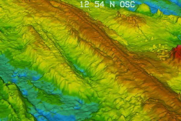
I have no idea what this is, any ideas? Looks like giant tubes undersea. They look rather big for lava tubes. If anyone wants to post a screen print that would be great. I have no idea how.
Here we go.

- Home
- Forum
- Chat
- Donate
-
Site Links

-
Avalon Library
-
External Sites
- Solari Report | Catherine Austin Fitts
- The Wall Will Fall | Vanessa Beeley
- Unsafe Space | Keri Smith
- Giza Death Star | Joseph P. Farrell
- The Last American Vagabond
- Caitlin Johnstone
- John Pilger
- Voltaire Network
- Suspicious Observers
- Peak Prosperity | Chris Martenson
- Dark Journalist
- The Black Vault
- Global Research | Michael Chossudovsky
- Corbett Report
- Infowars
- Natural News
- Ice Age Farmer
- Dr. Joseph Mercola
- Childrens Health Defense
- Geoengineering Watch | Dane Wigington
- Truthstream Media
- Unlimited Hangout | Whitney Webb
- Wikileaks index
- Vaccine Impact
- Eva Bartlett (In Gaza blog)
- Scott Ritter
- Redacted (Natalie & Clayton Morris)
- Judging Freedom (Andrew Napolitano)
- Alexander Mercouris
- The Duran
- Simplicius The Thinker
 Reply With Quote


Bookmarks